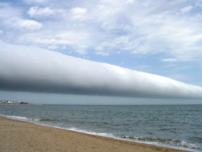
I am putting this picture in after multiple requests from my brother, Danny, a regular reader of this blog. The reason I didn't put it in when he first sent it was because as astounding a meteorological phenomenon as it is, the picture didn't have that certain je ne sais quoi that makes me snap to. It's a little flat. But I don't want him to feel bad, and so I'll let the readers tell me whether it was worth posting.
FYI - this picture, taken in January 2009 at Las Olas Beach in Maldonado, Uruguay, shows a rare roll cloud. These clouds form when a downdraft from an advancing storm front causes moist warm air to rise and then cool below its dew point. When this happens uniformly along an extended front, a roll cloud may sometimes form.